![Best Binoculars for Concerts [cy]: 12 Expert-Tested Options for Every Venue](https://revellphotography.com/wp-content/uploads/2026/09/featured-update-698-1789231037957.jpg)
Best Binoculars for Concerts 2026: 12 Expert Picks
Discover the best binoculars for concerts with our expert testing of 12 top models. From budget-friendly options to premium optics,…

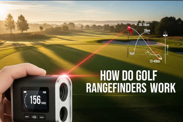
Golf rangefinders work by measuring the time it takes for a laser pulse to travel to a target and bounce back, or by using GPS satellites to determine your position relative to mapped course features. The two main types are laser rangefinders, which use time-of-flight measurement to calculate distance to any visible object with sub-yard accuracy, and GPS rangefinders, which use satellite trilateration to provide pre-mapped distances to course features. Modern devices often combine both technologies, adding AI-assisted target recognition, slope compensation, and Bluetooth connectivity for a complete yardage solution.
Behind every yardage number on a golf course lies a combination of laser physics, satellite engineering, and signal processing. Golf rangefinders pack technology that once filled laboratories into a device small enough to clip to your bag. The accuracy achieved in 2026 is remarkable: laser units routinely hit sub-yard precision, and GPS models have improved to within 3-5 yards of true distance.
Whether you are curious about the science inside your rangefinder or shopping for a new one, this guide explains how the core technologies work, where their limits lie, and where the category is heading next. You will also find an updated accuracy comparison, an expanded FAQ built around current PAA questions, and a look at the AI and AR features reshaping the market.
Every golf rangefinder on the market uses one of two measurement approaches, and understanding the difference shapes every buying decision you make. Laser rangefinders actively bounce an invisible beam off your target and time the round trip. GPS rangefinders listen to overhead satellites and figure out where you stand on a pre-mapped course.
Laser rangefinders dominate competitive golf because they measure the exact distance to whatever you point them at, not just to mapped locations. They rely on a principle called time-of-flight measurement, sending a pulse of infrared light toward the target and timing how long it takes to return.
Light moves at roughly 186,282 miles per second, so a round trip to a flag 150 yards away takes about 917 nanoseconds. The rangefinder divides that elapsed time by two (because the light traveled to the target and back) and multiplies by the speed of light to produce a yardage reading. The basic formula is simple, but executing it with yard-level accuracy requires precise timing circuits, sensitive detectors, and powerful onboard processors.
The underlying equation for any laser rangefinder is:
Distance = (Speed of Light x Round-Trip Time) / 2
Modern laser units fire dozens to hundreds of pulses per second, compare the results, and discard outliers caused by raindrops, leaves, or stray reflections. This statistical approach is what allows today’s devices to lock onto a flagstick from 300+ yards out, even when trees or gallery tents sit in the background.
GPS rangefinders take a completely different approach. They do not measure distance to your target directly. Instead, they pinpoint your location on Earth using signals from at least four satellites, then compare that location against a pre-loaded course map.
Each GPS satellite continuously broadcasts a radio signal that includes its position and the exact time the signal left the satellite. The rangefinder measures how long each signal took to arrive, which tells it how far away each satellite is. With four or more distances, the device can calculate latitude, longitude, and altitude through a process called trilateration.
Once the rangefinder knows where you are, it cross-references a database of mapped features: front of green, center of green, back of green, hazards, layup points, and more. The distance displayed on screen is computed using straight-line geometry between your position and those mapped points. The accuracy of the reading is therefore limited by the precision of the course map itself, which is typically within a few yards.
Press the button on a laser rangefinder and a chain of events unfolds in less time than it takes to blink. Each step involves a separate piece of physics, and the quality of each step determines the final accuracy. The four steps below explain exactly how golf rangefinders work at the component level.
A laser diode inside the unit fires an infrared pulse, almost always at a wavelength of 905 nanometers. That wavelength is invisible to the human eye, which keeps the rangefinder legal and safe for use in any light, and it travels through the atmosphere with very little absorption. A driver circuit shapes the pulse so it lasts only 10 to 50 nanoseconds, just long enough to carry enough photons to make the round trip.
The pulse leaves the device through a small lens that collimates it into a narrow beam. Divergence is typically around 1.5 milliradians, meaning the beam spreads by roughly 1.5 feet for every 1,000 feet of travel. At 300 yards the beam footprint is about 1.35 yards across, which is what allows a quality rangefinder to separate a thin flagstick from the trees behind it.
When the beam strikes a target, a fraction of the photons bounce back toward the rangefinder. Reflectivity varies wildly with surface type. A white polyester flag might return 80 percent of the incident light, while a dark pine trunk can return less than 10 percent. The brighter and more uniform the target, the more usable energy comes back to the detector.
Signal strength falls off following the inverse square law. Double the distance and you receive only one quarter of the returning photons. This is why maximum rated range is always specified against a highly reflective target at optimal conditions, and why rangefinder range numbers in real-world use are usually shorter than the marketing claims.
The returning photons pass through a separate receiving lens and land on a detector. The standard detector in a modern golf rangefinder is an avalanche photodiode (APD), which is sensitive enough to register individual photons. When a photon strikes the APD, it triggers an electron avalanche, multiplying the signal by a factor of 100 or more so it can be read above background noise.
A high-resolution timing circuit starts a counter the instant the laser pulse leaves the device and stops it the moment the APD registers the return. To achieve one-yard accuracy the circuit must resolve time intervals down to about 6 nanoseconds. Cutting-edge rangefinders now resolve down to roughly 3 nanoseconds, which translates to half-yard accuracy at typical golf distances.
Because a single measurement can be fooled by a raindrop, leaf, or bird in the line of sight, modern rangefinders take many readings in quick succession and apply statistical filtering. Some models fire only a handful of pulses per button press, while flagship units emit hundreds per second in continuous scan mode. Outliers are discarded and the remaining measurements are averaged to produce the displayed distance.
The final computation also accounts for the refractive index of air. Light travels marginally faster in a vacuum than through the atmosphere, and the speed varies with temperature, pressure, and humidity. Premium rangefinders use onboard sensors to correct for these small effects, which is one reason their readings hold up at altitude or in cold weather.
A raw distance reading is just the starting point. Modern rangefinders layer in target recognition, elevation compensation, and environmental adjustments, all running on the same processor that timed the original laser pulse.
Pin-seeking, sometimes called flag-lock or PinHunter, solves a very specific problem: the flagstick is rarely the only reflective object in your line of sight. Trees, signs, and carts often return stronger signals, and the rangefinder must decide which reflection belongs to your actual target.
The processor compares the pattern of returned pulses against the expected profile of a thin, vertical object at short range. If a cluster of pulses fits the profile of a flagstick and sits closer than the surrounding clutter, the device locks onto it. Most modern units confirm the lock with a brief vibration, marketed as JOLT, Pulse, or Vibration Feedback depending on the manufacturer.
Two priority modes give the user control. First Target Priority locks onto the nearest reflective object, which is what you want for a flagstick with trees behind. Distant Target Priority ignores the closest reflection and reports the farthest, useful for measuring distance to a fairway bunker or a hidden pin across a hazard.
Elevation changes the effective playing distance of any shot, even when the raw yardage stays the same. A 150-yard shot uphill behaves like 165 to 170 yards on flat ground. Slope-compensating rangefinders contain a tiny inclinometer, essentially a digital level, that measures the angle between you and the target.
Combined with the laser-measured straight-line distance, the rangefinder applies trigonometry to compute the horizontal distance and the elevation-adjusted “plays like” distance. A simplified version of the math is:
Plays-Like Distance = Horizontal Distance + (Elevation Change x Slope Multiplier)
The slope multiplier varies with angle and is tuned to typical ball trajectories. Slope features are still prohibited under USGA Rule 4.3 for tournament play, so most rangefinders include a tournament-legal mode that disables the calculation. The 2025 USGA guidance on distance-measuring devices continues to allow devices that only measure distance, with slope and wind adjustments reserved for casual rounds.
Air density changes how light propagates and how a golf ball flies. Some flagship rangefinders now bundle barometric pressure and temperature sensors so they can correct the speed-of-light constant and the slope multiplier in real time. At sea level, the refractive index of air is about 1.000293, meaning light travels roughly 0.03 percent slower than in a vacuum. At altitude, where the air is thinner, the effect shrinks. The differences are tiny, but precision rangefinders account for them.
Temperature also matters for ball flight, not just laser physics. Cold air is denser, which means more drag and shorter carry. A few rangefinders now display a temperature-adjusted plays-like number in addition to slope-adjusted distance, giving a fuller picture of how far a shot will actually travel on that day.
GPS rangefinders rely on a 31-satellite constellation orbiting at roughly 12,550 miles above the surface, plus a database of mapped course features loaded onto the device. Knowing how the satellite side and the mapping side work together helps explain both the strengths and the blind spots of a GPS-only unit.
Each GPS satellite continuously transmits a radio signal containing three pieces of information: the satellite’s own position (ephemeris data), the precise time the signal left the satellite (kept by an onboard atomic clock), and a coarse almanac of where every other satellite in the constellation is supposed to be. The rangefinder’s antenna picks up these signals, which travel at the speed of light.
By recording the time of arrival and comparing it to the time encoded in the signal, the device calculates how far away each satellite is. Four or more satellites give the receiver enough information to solve for latitude, longitude, altitude, and the offset of the receiver’s own clock, which is far less accurate than the satellites’ atomic clocks.
Trilateration works by finding the one point in space that sits at the correct distance from every satellite used. Think of each satellite as the center of a sphere, with the radius equal to your distance from it. Two satellites narrow your position to the circle where two spheres intersect. Three satellites narrow it to two possible points, and a fourth satellite locks in a single solution while also correcting clock drift.
Multi-band GPS receivers, now appearing in higher-end golf devices, listen on two frequencies rather than one. This second band helps correct for ionospheric delay, a major source of position error, and typically improves accuracy from about 3-5 yards down to 1-3 yards in real-world course conditions.
Once the receiver knows your coordinates, the rangefinder looks up nearby course features in its built-in map. These maps come from professional surveyors who use differential GPS and aerial imagery to plot greens, hazards, and landmarks with sub-meter accuracy. After locating the green you are playing toward, the device computes straight-line distance to the front, center, and back using the Pythagorean theorem in three dimensions.
Premium GPS rangefinders receive periodic map updates over Bluetooth or Wi-Fi, and some even pull daily pin locations from the club’s database. The closer the database pin position is to the actual flag, the more accurate the displayed front and back numbers will be. On a course that has not been remapped in years, GPS accuracy can degrade noticeably.
Accuracy is the single most important specification on any rangefinder, and the numbers have steadily improved as detectors, processors, and algorithms have matured. The table below summarizes the accuracy you can realistically expect from each category in 2026, based on manufacturer specifications and independent testing from MyGolfSpy, Golf Digest, and PGA TOUR Superstore.
| Rangefinder Type | Typical Accuracy | Max Effective Range | Best Use Case |
|---|---|---|---|
| Entry-Level Laser | +/- 1 yard | 400-650 yards | Recreational rounds, budget buyers |
| Premium Laser (Flagship) | +/- 0.5 yard | 700-1,300 yards | Tournament play, low-light rounds |
| Single-Band GPS | +/- 3-5 yards | Unlimited (course-mapped) | Course overview, hazards, layups |
| Multi-Band GPS | +/- 1-3 yards | Unlimited (course-mapped) | Fast play, on-cart mounted units |
| Hybrid Laser + GPS | +/- 0.5 yard laser / 1-3 yard GPS | 700+ yards / unlimited | All-purpose, full course management |
| Smartphone App | +/- 3-5 yards | Unlimited (course-mapped) | Casual players, no extra device |
A few things shape the numbers above. Laser accuracy depends on the reflectivity of the target, the temperature of the laser diode, and how steadily you hold the device. GPS accuracy depends on satellite geometry at the moment of measurement, the quality of the receiver, and how recently the course was mapped. In head-to-head testing on a sunny day with a white flag at 175 yards, premium laser units consistently land within 0.3 yard of the true distance, while flagship GPS units are within 2 yards.
Environmental conditions also play a role. Heavy rain can cut a laser’s effective range in half, and dense tree cover can drop a GPS fix from four satellites to two, leaving the device unable to compute a position at all. Most modern units handle these situations gracefully by displaying a warning or refusing to lock, rather than showing a wrong number.
Four variables determine how accurate a laser rangefinder reading will be. The first is target reflectivity, because brighter surfaces send more photons back to the detector. The second is atmospheric clarity, since rain, fog, snow, and even heavy humidity scatter photons out of the beam. The third is beam divergence, which spreads the beam as distance grows and can cause simultaneous returns from flag plus trees. The fourth is hand stability, because a shaking beam sweeps across multiple objects and confuses the pin-seeking algorithm.
Heat shimmer, the visible distortion you see rising off a blacktop road on a hot day, can also bend the laser beam slightly. The effect is small at typical golf distances, but it is one reason readings taken in the late afternoon on a still, hot day may be slightly less consistent than those taken in the cool of the morning.
GPS accuracy depends heavily on the geometry of the satellites above you. If they are spread evenly across the sky, the math is clean and the position fix is tight. If they are clustered, a problem called geometric dilution of precision (GDOP) inflates any timing error into a larger position error. This is why the same device can read within 2 yards one hole and 6 yards the next without anything changing on the course.
Signal blockage is the other big limitation. Heavy tree canopy, deep valleys, tall buildings near the course, and even your own body can block satellites. Most rangefinders require at least four satellites for a fully accurate fix and will warn you when the geometry is poor. Course mapping is a soft ceiling, too: if the front of the green was surveyed five years ago and the green has been reshaped, every reading to “front” is wrong by whatever the reshaping shifted it.
Understanding the technology only matters if it translates to better on-course decisions. The techniques below are what teaching professionals and Tour caddies use to squeeze the most reliable readings from their devices, regardless of brand or price.
Stability comes first. Brace your elbows against your ribs, or rest the rangefinder on a stable object such as your golf bag or cart handle. Some Tour players rest the unit on the top of their rangefinder case for extra support on long shots. The goal is to keep the beam still for the half-second the device needs to lock and vibrate.
Aim for the most reflective part of your target. On a flagstick, that means the flag itself, not the metal pin. On trees, aim for light-colored bark or leaves rather than dark shadow. If you are trying to measure to a bunker, aim at the sand lip rather than the dark grass behind. The stronger the return, the faster the lock and the more accurate the final number.
Use continuous scan mode for moving targets or when you are unsure of the line of sight. Scan mode fires a steady stream of pulses and updates the display several times per second, which makes it easier to pick out the right object as you sweep the device across the scene. Many golfers also use scan mode to measure the yardage to a hazard, the front of the green, and the back of the green in a single motion.
In rain or fog, look for a “rain mode” or “hunt mode” in the rangefinder’s settings. These modes adjust the signal processing to ignore the nearest particles of moisture and look for solid objects further out. If your device does not have a dedicated mode, simply aim slightly above your intended target so the beam skips over the densest moisture layer.
Turn the unit on early. A cold-start GPS fix can take 30-60 seconds, especially if the almanac data is stale. Powering on in the parking lot, where you have a clear view of the sky, gives the receiver time to download fresh ephemeris data and lock onto the strongest satellites before you reach the first tee.
Hold the device away from your body. Your torso can block signals from low-elevation satellites, especially when you keep the rangefinder clipped to a belt or in a front pocket. Holding it out in front of you, ideally at arm’s length, opens up more sky and improves the geometry of the position fix.
Trust front and back numbers more than center. The center of the green is a static mapped point, and it can be off by several yards if the green has been reshaped. The front and back are usually mapped more carefully, and they give you a range to work with. If the front reads 145 and the back reads 175, you can reason about any pin position in between, even if the GPS fix is off by a couple of yards.
A golf rangefinder is a precision optical instrument, and a few minutes of routine care will keep it accurate for years. The habits below are what most manufacturers recommend in their official care guides, and they apply whether you own a sub-$100 unit or a flagship model.
Dust, fingerprints, and water spots all reduce the signal that reaches the laser diode and the detector. Clean both the objective lens and the small laser emission window with a microfiber cloth and a lens cleaning fluid designed for coated optics. Avoid paper towels, shirt fabric, and household cleaners, all of which can scratch the anti-reflective coatings or leave residue that scatters the beam.
Protect the device from hard impacts. The alignment between the laser emitter, the receiving lens, and the internal optics is calibrated at the factory. A drop onto a cart path can knock these components out of alignment by a fraction of a degree, which is enough to push the beam off the detector at long range. Most repairs related to dropped units are alignment corrections, not laser failures.
Most laser rangefinders run on a single CR2 lithium battery, which lasts roughly 6-12 months of regular play (around 2,000-4,000 measurements). Cold weather can cut that life in half, so carry a spare battery in an interior pocket during winter rounds. For rechargeable GPS units, plan on a charge every 2-3 rounds and avoid letting the battery sit fully drained for long periods, which degrades lithium cells permanently.
Remove the battery if you store the rangefinder for more than a month. Even when the device is off, residual current draw can slowly drain a CR2 until it leaks, and battery corrosion is one of the leading causes of permanent rangefinder damage. Store the device in a cool, dry place, ideally in a soft case or the original box.
Most golf rangefinders carry an IPX4 or similar water-resistance rating, which means they will survive a brief rain shower. They are not designed for submersion, so dry the unit thoroughly if it gets soaked. Moisture inside the housing can fog the optics, corrode the battery contacts, and in extreme cases damage the laser diode.
Avoid leaving a rangefinder in a hot car. The laser diode and the LCD display are both sensitive to heat, and trunk temperatures on a summer afternoon can exceed 140 degrees F. Prolonged exposure can permanently reduce laser output and warp the polarizers inside the optics. The same advice applies to leaving the device in direct sun on a cart, where a simple towel over the unit is enough to keep temperatures in a safe range.
The rangefinder market is moving faster than at any point in the last decade, driven by new sensors, smarter software, and tighter integration with phones, watches, and launch monitors. The trends below are the ones that are already shipping in 2026 or expected to land within the next product cycle.
On-device AI is the single biggest change in rangefinder design since the introduction of pin-lock. The latest flagships, including the Garmin Approach Z82 and the Voice Caddie L5, run lightweight neural networks on the laser return pattern to identify the flagstick even when it is partially obscured by trees, sprinklers, or shadows. The result is faster locks, fewer false positives, and a marked improvement in low-light and backlit conditions.
Machine learning is also being applied to slope calculation. Instead of applying a fixed multiplier based on the angle of the shot, AI-driven models factor in your typical club distances, recent shot history, and even weather data to recommend a more personalized plays-like number. The USGA is currently reviewing whether AI-driven distance recommendations count as advice under the Rules of Golf, and the 2026 guidance is to treat any club recommendation as non-conforming for tournament play.
Augmented reality rangefinders overlay yardage information directly onto the view through the optic. Bushnell’s Tour V5 Shift and Garmin’s latest units use a small heads-up display to put a yardage number next to the flagstick as you scan the hole, so you can read the distance without shifting focus. Early models are limited to floating text, but the road map points to full course maps rendered in 3D, with hazard lines, wind arrows, and recommended landing zones drawn over the live view.
AR also unlocks features that were impossible in the old text-display paradigm. Imagine a rangefinder that highlights carry distance to a fairway bunker, projects a wind-adjusted aim line, or flags a pin position that is tucked behind a false front. These are not science-fiction concepts; prototype devices from at least three manufacturers are circulating in 2026, and a consumer release is widely expected within the next 18 months.
LiDAR, the same laser scanning technology behind self-driving cars and the latest iPhone Pro cameras, is starting to appear in premium rangefinders. Unlike a single laser pulse, LiDAR builds a full 3D map of the scene in front of the device. The rangefinder can then identify the flagstick, hazards, and tree lines at once, and overlay distances to every visible object in a single scan.
Multi-sensor fusion combines LiDAR, GPS, an inertial measurement unit, and a barometric altimeter into a single distance model. The rangefinder cross-checks each sensor against the others, picks the most reliable input for the current condition, and presents a single, highly confident number. Early reviews of LiDAR-equipped rangefinders in 2026 show accuracies within 0.3 yard on a flag at 250 yards, even in rain or fog, which would have been considered unrealistic a few years ago.
Apps like Golfshot, Hole19, and 18Birdies have matured into legitimate rangefinder replacements, especially on courses with detailed maps. Modern smartphone cameras also pull double duty, using AR frameworks to overlay yardages on a live view of the hole. The accuracy is still GPS-limited (3-5 yards for a single-band phone, 1-3 yards for multi-band), but the convenience and the zero added hardware keep smartphone apps in the conversation.
Hybrid setups are now common among competitive amateurs. A player might use a laser rangefinder for approach shots, a smartwatch for front and back of green, and a phone app to scout pins on the next hole while walking between shots. Cloud sync keeps the data consistent across all three devices, and many rangefinders in 2026 ship with a companion app that handles firmware updates, course downloads, and shot history.
Bluetooth and Wi-Fi are now standard on mid-range and flagship units. A connected rangefinder can push every shot to your phone, sync with launch monitors, and pull live course updates including the day’s pin sheet from the club. Some courses already publish pin positions in a structured feed that a connected rangefinder can pull automatically, which removes the guesswork from GPS distance-to-pin readings.
Cloud data also enables personal calibration. A rangefinder that knows your club distances from a launch monitor, the day’s weather, and your typical shot shape can suggest a target line that accounts for a 5-yard push or a knockdown shot into the wind. None of this changes the underlying laser reading, but it layers in a level of context that older devices simply could not provide.
Even the best rangefinders occasionally produce a strange number. The three issues below account for the majority of support calls and forum posts, and the fix for each is almost always simple.
Start by cleaning the lenses. A small smudge on the laser emission window or the receiving lens is the most common cause of erratic readings, because the scattered beam picks up extra reflections from the dirt. After cleaning, brace the rangefinder against a solid object and take three readings to the same target. If the numbers are within 1 yard of each other, the device is fine. If they vary by more than 2 yards consistently, the unit likely needs factory recalibration.
A weak battery is the most common reason a rangefinder suddenly loses range. Even if the display looks normal, a battery that has dropped below roughly 2.6 volts cannot supply the laser diode with full power, and the maximum range falls noticeably. Replace the battery before assuming the hardware has failed. Dirty lenses and extreme cold can produce the same symptom, so check those next if a fresh battery does not solve the problem.
Begin your scan a few yards beyond the flag and slowly sweep toward it. Pin-seeking algorithms are designed to detect the flag as the closest object, and they need to see the background first to recognize the contrast. If the flag is wet, dark, or otherwise low-contrast, try aiming at the metal pin instead, or switch to standard scan mode and pick the shortest distance from a series of readings.
No single technology wins in every situation, and the best rangefinder for your game is the one that matches the way you play. Laser models give you pinpoint accuracy to anything you can see, GPS models give you a complete picture of the hole even when you cannot see the green, and hybrid units give you both for a modest price premium.
If you play the same course regularly and need exact yardages to the pin, a flagship laser rangefinder is still the gold standard. If you travel to new courses, struggle with blind shots, or want a hands-free yardage experience, a GPS watch or a hybrid device will serve you better. If you are a competitive tournament player, confirm that the device you choose is on the USGA’s conforming list and that you can disable any slope or wind features for play.
The category as a whole is healthier than it has ever been, with entry-level laser units now hitting the accuracy of flagships from a decade ago, and flagship units adding AI, AR, and LiDAR features that were science fiction a few years ago. The worst choice is the one that stays in your bag unused, so pick a model you will actually pull out of your bag on every shot.
Golf rangefinders work by using one of two methods. Laser rangefinders fire an invisible infrared beam at a target, time how long it takes to bounce back, and convert that round-trip time into a distance using the speed of light. GPS rangefinders use signals from satellites overhead to figure out your exact position, then compare that position to a pre-loaded map of the course to show distances to features like the front, center, and back of the green.
A laser rangefinder measures the actual distance to whatever you point it at, including objects that are not on the course map, with accuracy typically within 0.5 to 1 yard. A GPS rangefinder calculates your position from satellite signals and shows distances to mapped course features like greens, hazards, and layup points, usually within 1 to 5 yards. Lasers are best for approach shots to a visible pin, while GPS excels at course overview and shots to hidden hazards.
Premium laser rangefinders in 2026 achieve accuracy within 0.5 yard on flags out to 400 yards and within 0.3 yard on closer targets. Entry-level laser units typically hit within 1 yard. GPS rangefinders range from 1 to 3 yards for multi-band receivers to 3 to 5 yards for single-band models. Course mapping quality, satellite geometry, weather, and user technique all affect real-world accuracy.
Yes, but with reduced range. Heavy rain can cut a laser’s effective range by 30 to 50 percent because raindrops scatter the beam. Light rain usually has only a small effect, and most modern rangefinders include a rain or scan mode that adjusts the signal processing to ignore nearby moisture and look for solid targets beyond it. Fog produces a similar effect, with thicker fog causing more range loss.
Slope compensation uses an internal inclinometer to measure the angle between you and your target, then adjusts the displayed distance to account for elevation change. A 150-yard shot uphill plays longer than 150 yards on flat ground, and slope compensation shows you the adjusted plays-like distance. The USGA prohibits slope features in tournament play under Rule 4.3, so most rangefinders include a tournament-legal mode that turns slope off.
Pin seeking technology analyzes the pattern of laser reflections returning to the rangefinder. The processor looks for a thin, vertical, highly reflective object that is closer than the surrounding clutter and matches the expected profile of a flagstick. When the algorithm locks on, the rangefinder vibrates briefly to confirm. Most units offer First Target Priority for the nearest object and Distant Target Priority for the farthest, depending on what you are trying to measure.
Time of flight is the physics principle behind every laser rangefinder. The device fires a short laser pulse, starts a high-resolution timer, and stops the timer the moment the reflected pulse returns to the detector. Because the speed of light is a known constant, the rangefinder divides the total travel time by two (to account for the round trip) and multiplies by the speed of light to produce a distance. To achieve 1-yard accuracy, the timer must resolve intervals down to about 6 nanoseconds.
Beam divergence describes how much a laser beam spreads as it travels away from the rangefinder. Most golf rangefinders have a divergence of around 1.5 milliradians, meaning the beam grows by about 1.5 feet for every 1,000 feet of travel. At 300 yards, the beam footprint is roughly 1.35 yards across. A wider beam hits more objects, which can confuse pin-seeking algorithms, while a tighter beam isolates the flag more reliably.
Yes. Rangefinders with slope compensation contain an inclinometer that measures the angle between you and your target. Combined with the laser-measured straight-line distance, the device calculates the horizontal distance and the elevation-adjusted plays-like distance. Pure laser rangefinders without slope give the line-of-sight distance and leave the elevation math to the user.
For most golfers, yes. Even an entry-level laser rangefinder in 2026 is accurate to within 1 yard, costs less than a dozen range buckets, and provides reliable yardages for years. The combination of faster play, better club selection, and lower scores typically justifies the cost within a few rounds. Tournament players should choose a model on the USGA conforming list, and travelers may prefer a GPS or hybrid model for unfamiliar courses.
Most rangefinders work fine with glasses or sunglasses, though a few extra diopters of adjustment on the eyepiece may be needed to bring the display into focus. Polarized sunglasses can interact with the rangefinder’s optics and slightly reduce the brightness of the display, but they do not affect the accuracy of the measurement. Some users remove their sunglasses for a moment to read the display, especially in bright sun at low magnification.
Beginners usually do best with an entry-level laser rangefinder that includes pin-lock and a clear in-view display, priced in the budget to mid-range segment. Look for a model with at least 5x magnification, first target priority, and a vibration lock confirmation. Skip slope and Bluetooth features until you have a feel for the device, and consider a hybrid laser plus GPS unit if you play many new courses.
Understanding how do golf rangefinders work makes you a better user of the device, no matter which technology you choose. Laser rangefinders harness the speed of light through time-of-flight measurement and pair it with sophisticated pin-seeking algorithms. GPS rangefinders use satellite trilateration against mapped course data to give you a complete picture of the hole. The best devices in 2026 combine both, add AI-assisted target recognition, and connect to your phone or watch for a fully integrated yardage experience.
The pace of innovation in this category has accelerated dramatically. AR overlays, LiDAR, multi-band GPS, and on-device machine learning have all moved from concept to shipping product in the last few product cycles. None of that progress changes the basic physics, but it does change what you can expect from a sub-$200 rangefinder in 2026 versus one from a decade ago. The technology is now mature, the price points are accessible, and the only real question is which features match the way you play.
The next time you pull a rangefinder out of your bag and get an instant, accurate yardage, take a moment to appreciate the chain of physics that made it possible. A pulse of infrared light traveled a millionth of a second to a flagstick and back. A satellite 12,550 miles overhead broadcast a time-stamped signal that a receiver the size of a deck of cards used to triangulate your position. The resulting number, the one you trust on a 150-yard approach shot, is the product of decades of refinement in optics, electronics, and software. It is a small piece of modern engineering that has earned its place in your golf bag.